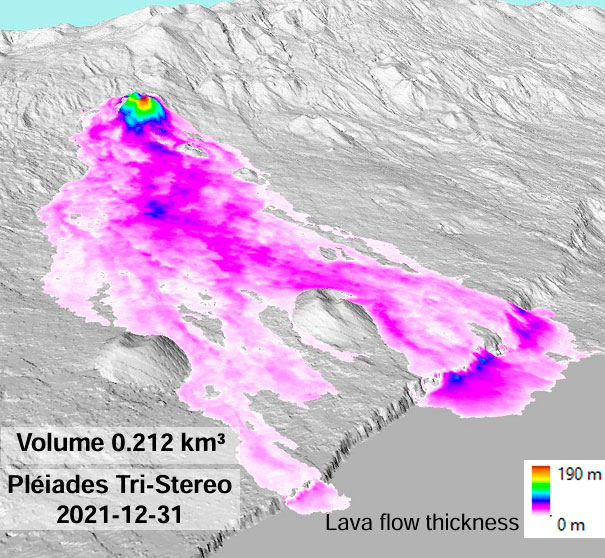
Photo: Plank, S., Shevchenko, A.V., d’Angelo, P., Gstaiger V., González, P.J., Sesca, S., Martinis, S., Walter, T.R. (2023). Combining thermal, tri-stereo optical and bi-static InSAR satellite imagery for lava volume estimates: the 2021 Cumbre Vieja eruption, La Palma. Sci. Rep. 13: 2057.
Geophysical and geodetic monitoring are essential for understanding the dynamics of volcanic and tectonic systems. By tracking ground deformation, seismic activity, and gravity changes, researchers can gain insights into subsurface processes such as magma migration, fault movements, and stress accumulation. This session will highlight recent advances in geophysical and geodetic techniques, including the use of high-resolution GPS, InSAR, and seismic networks to enhance real-time monitoring and hazard assessment.
The session will feature discussions on integrating multiple data sources to improve early warning capabilities. Case studies from active volcanic and tectonic regions will demonstrate how modern geodetic methods provide critical information for forecasting eruptions, assessing structural stability, and mitigating risks. Additionally, the role of AI and machine learning in processing vast geodetic datasets will be explored, offering new opportunities to enhance data interpretation and predictive modeling.
Bringing together experts from diverse fields, this session aims to foster collaboration between geophysicists, geodesists, and data scientists. Participants will engage in discussions on technological innovations, challenges in data integration, and future directions in monitoring and modeling. By advancing geophysical and geodetic approaches, this session will contribute to improving hazard assessment, infrastructure resilience, and scientific understanding of Earth’s dynamic processes.